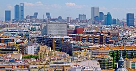
ມາດິດ
ມາດິດ (ພາສາສະເປນ: Madrid) ເປັນນະຄອນຫຼວງແລະ ເທດສະບານທີ່ມີປະຊາກອນຫຼາຍທີ່ສຸດຂອງສະເປນ. ມັນມີເກືອບ 3.4 ລ້ານຄົນ[7] ອາໃສແລະປະຊາກອນ ເຂດນະຄອນ ຂອງປະມານ 7 ລ້ານ. ເປັນ ເມືອງໃຫຍ່ອັນດັບສອງ ຂອງ ສະຫະພາບເອີລົບ (EU), ແລະ ເຂດມະຫານະຄອນ ທີ່ເປັນໃຈກາງ ຂອງຕົນແມ່ນເມືອງ ໃຫຍ່ອັນດັບສອງ ຂອງ EU.[8][9] ເທດສະບານກວມເອົາ 604.3 ກິໂລແມັດ ພື້ນທີ່ທາງພູມສາດ.[10] ມາດິດ ຕັ້ງຢູ່ເທິງ ແມ່ນ້ໍາ Manzanares ໃນພາກກາງຂອງ ແຫຼມອີເບລີ ຢູ່ທີ່ປະມານ 650 ແມັດເຫນືອລະດັບນ້ໍາທະເລ. ນະຄອນຫຼວງຂອງທັງສະເປນແລະ ປະຊາຄົມປົກຄອງຕົນເອງອ້ອມຂ້າງຂອງ ມາດິດ (ນັບຕັ້ງແຕ່ 1983), [11] :44ມັນຍັງເປັນສູນກາງທາງດ້ານການເມືອງ, ເສດຖະກິດ, ແລະວັດທະນະທໍາຂອງປະເທດ.[12] ສະພາບອາກາດຂອງ ມາດິດ ມີລັກສະນະຮ້ອນຮ້ອນແລະລະດູຫນາວເຢັນ. ຫຼັກຖານຕົ້ນຕໍຂອງ ມາດິດ, ເປັນຖານທັບທາງທະຫານທີ່ມີກຳແພງ, ມີມາແຕ່ທ້າຍສັດຕະວັດທີ 9, ພາຍໃຕ້ສະ ຫະລັດ Emirate ຂອງ Córdoba. ເອົາຊະນະໂດຍຊາວຄຣິດສະຕຽນໃນປີ 1083 ຫຼື 1085, ມັນໄດ້ລວມຢູ່ໃນຍຸກກາງທ້າຍເປັນເມືອງທີ່ມີຂະຫນາດຂອງ ເຮືອນຍອດຂອງ Castile . ການພັດທະນາຂອງ ມາດິດ ເປັນສູນກາງການບໍລິຫານໄດ້ອຸປະຖໍາຫຼັງຈາກ 1561, ຍ້ອນວ່າມັນໄດ້ກາຍເປັນບ່ອນນັ່ງຖາວອນຂອງສານຂອງ ປະຊາຊົນ Hispanic.
ມາດິດ | |
|---|---|
| ແມ່ແບບ:Infobox mapframe ທີ່ຕັ້ງຂອງ ມາດິດ | |
| Lua error in Module:Location_map at line 526: Unable to find the specified location map definition: "Module:Location map/data/Spain" does not exist. | |
| ພິກັດ: 40°25′01″N 03°42′12″W / 40.41694°N 3.70333°Wພິກັດພູມສາດ: 40°25′01″N 03°42′12″W / 40.41694°N 3.70333°W | |
| ປະເທດ | ສະເປນ |
| Autonomous community | Community of Madrid |
| Founded | ສະຕະວັດທີ 9 |
| ການປົກຄອງ | |
| • ປະເພດ | Ayuntamiento |
| • ໜ່ວຍງານ | City Council of Madrid |
| • Mayor | José Luis Martínez-Almeida (PP) |
| ພື້ນທີ່ | |
| • ນະຄອນຫຼວງ ແລະ ເທດສະບານ | 604.31 ຕລ.ກມ. (230 ຕລ.ໄມລ໌) |
| ຄວາມສູງ | 650 ແມັດ (2,100 ຟຸດ) |
| ປະຊາກອນ | |
| • ນະຄອນຫຼວງ ແລະ ເທດສະບານ | ແມ່ແບບ:Spain metadata Wikidata ຄົນ |
| • ອັນດັບ | 2nd in the European Union 1st in Spain |
| • ເຂດເມືອງ | 6,211,000[2] ຄົນ |
| • ລວມເຂດ | 6,791,667[1] ຄົນ |
| ເດມະນິມ | Madrilenian, Madrilene madrileño, -ña; matritense, gato, -a |
| GDP[3] | |
| • Capital city and municipality | €135.6 billion (2020)[4] |
| • Metro | €261.7 billion (2022)[5] |
| ເຂດເວລາ | UTC+1 (CET) |
| • ລະດູຮ້ອນ (ເວລາອອມແສງ) | UTC+2 (CEST) |
| Postal code | 28001–28080 |
| ລະຫັດພື້ນທີ່ | +34 (ES) + 91 (M) |
| HDI (2021) | 0.940[6] very high · 1st |
| ເວັບໄຊ | https://madrid.es |
ອ້າງອີງ
ດັດແກ້- ↑ "Population on 1 January by age groups and sex – functional urban areas". Eurostat. Archived from the original on 3 September 2015. Retrieved 12 December 2016.
- ↑ "Demographia World Urban Areas" (PDF). Demographia. 2022. Archived (PDF) from the original on 5 August 2011. Retrieved 26 July 2022.
- ↑ "Gross domestic product (GDP) at current market prices by metropolitan regions". ec.europa.eu. Archived from the original on 15 February 2023.
- ↑ "Indicador del PIB por zonas estadísticas y por municipios", www.madrid.org (in ສະແປນນິຊ)
- ↑ "EU regions by GDP, Eurostat". www.ec.europa.eu. Retrieved 18 September 2023.
- ↑ "Sub-national HDI – Area Database – Global Data Lab". hdi.globaldatalab.org (in ອັງກິດ). Archived from the original on 23 September 2018. Retrieved 26 June 2023.
- ↑ "Cifras oficiales de población resultantes de la revisión del Padrón municipal a 1 de enero".
{{cite web}}:|archive-url=requires|archive-date=(help);|archive-url=requires|url=(help); Missing or empty|url=(help) - ↑ "Major Agglomerations of the World".
{{cite web}}:|archive-url=requires|archive-date=(help);|archive-url=requires|url=(help); Missing or empty|url=(help) - ↑ United Nations Department of Economic and Social Affairs World Urbanization Prospects (2007 revision) Archived 2017-05-25 at the Wayback Machine, (United Nations, 2008), Table A.12.
- ↑ "Member of the Governing Council. Delegate for Economy, Employment and Citizen Involvement".
{{cite web}}:|archive-url=requires|archive-date=(help);|archive-url=requires|url=(help); Missing or empty|url=(help) - ↑ The Routledge Handbook of Spanish in the Global City.
- ↑ Madrid.


