Module:Location map/data/Indonesia
| name | ປະເທດອິນໂດເນເຊຍ | |||
|---|---|---|---|---|
| border coordinates | ||||
| 6.5 | ||||
| 94.5 | ←↕→ | 141.5 | ||
| -11.5 | ||||
| map center | 2°30′S 118°00′E / 2.5°S 118°E | |||
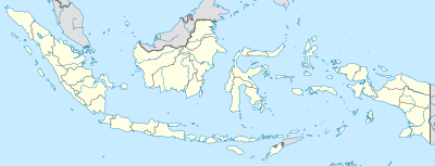
| image | Indonesia location map.svg
| |||

| ||||
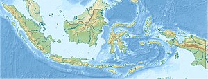
| image1 | Indonesia relief location map.jpg
| |||

| ||||

Module:Location map/data/Indonesia ແມ່ນໂມດູລນິຍາມແຜນທີ່ແມ່ແບບ equirectangular projection ຂອງປະເທດອິນໂດເນເຊຍ ເພື່ອໃຊ້ກຳນົດຕຳແໜ່ງໃນແຜນທີ່ຄ່າເລີ່ມຕົ້ນ ຫຼື ແຜນທີ່ໃກ້ຄຽງດ້ວຍສັນຍະລັກ ຫຼື ຂໍ້ຄວາມໂດຍໃຊ້ຄ່າພິກັດເສັ້ນຂະໜານ ແລະ ເສັ້ນແວງ
ການໃຊ້ງານ
ເມື່ອກຳນົດຄ່າພາລາມິເຕີ "Indonesia" ລົງໃນແມ່ແບບຕ່າງໆ ດ້ານລຸ່ມ ຈະໃຊ້ຄ່ານິຍາມຈາກໂມດູລນີ້
- {{Location map | Indonesia | ...}}
- {{Location map many | Indonesia | ...}}
- {{Location map+ | Indonesia | ...}}
- {{Location map~ | Indonesia | ...}}
ຄ່ານິຍາມ
name = ປະເທດອິນໂດເນເຊຍ- ຊື່ທີ່ໃຊ້ໃນຄຳອະທິບາຍແຜນທີ່ຄ່າເລີ່ມຕົ້ນ (default map)
image = Indonesia location map.svg- ຮູບພາບແຜນທີ່ຄ່າເລີ່ມຕົ້ນ ບໍ່ຕ້ອງໃສ່ "Image:" ຫຼື "File:" (ຫຼື "ຮູບ:" ຫຼື "ໄຟລ໌:")
image1 = Indonesia relief location map.jpg- ຮູບພາບແຜນທີ່ທາງເລືອກ (alternative map) ມັກຈະເປັນແຜນທີ່ພູມສັນຖານ (relief map) ເຊິ່ງກຳນົດໃຫ້ສະແດງໄດ້ໂດຍໃຊ້ພາລາມິເຕີ relief ຫຼື AlternativeMap
top = 6.5- ຄ່າເສັ້ນຂະໜານຂອງຕຳແໜ່ງຂອບເທິງສຸດຂອງແຜນທີ່ໃນຄ່າທົດສະນິຍົມ (decimal degrees)
bottom = -11.5- ຄ່າເສັ້ນແວງຂອງຕຳແໜ່ງຂອບລຸ່ມສຸດຂອງແຜນທີ່ໃນຄ່າທົດສະນິຍົມ
left = 94.5- ຄ່າເສັ້ນແວງຂອງຕຳແໜ່ງຂອບຊ້າຍສຸດຂອງແຜນທີ່ໃນຄ່າທົດສະນິຍົມ
right = 141.5- ຄ່າເສັ້ນແວງຂອງຕຳແໜ່ງຂອບຂວາສຸດຂອງແຜນທີ່ໃນຄ່າທົດສະນິຍົມ
ແຜນທີ່ທາງເລືອກ (Alternative map)
The {{Location map}}, {{Location map many}}, and {{Location map+}} templates have parameters to specify an alternative map image. The map displayed as image1 can be used with the relief or AlternativeMap parameters. Examples may be found below or in the following:
- Template:Location map#Relief parameter
- Template:Location map+/relief
- Template:Location map#AlternativeMap parameter
- Template:Location map+/AlternativeMap
ຄວາມຊັດເຈນ
ເສັ້ນແວງ: ຄ່ານິຍາມແຜນທີ່ນີ້ມີຂະໜາດຈາກທິດຕາເວັນຕົກ ຫາ ທິດຕາເວັນອອກ 47 ອົງສາ
- ພາບຂະໜາດຄວາມກວ້າງ (width) 200 ພິກເຊວ ທຽບອັດຕາສ່ວນໄດ້ 0.235 ອົງສາຕໍ່ພິກເຊວ
- ພາບຂະໜາດຄວາມກວ້າງ (width) 1,000 ພິວເຊວ ທຽບອັດຕາສ່ວນໄດ້ 0.047 ອົງສາຕໍ່ພິກເຊວ
ເສັ້ນຂະໜານ: ຄ່ານິຍາມແຜນທີ່ນີ້ມີຂະໜາດຈາກທິດເໜືອ ຫາ ທິດໃຕ້ 18 ອົງສາ
- ພາບຂະໜາດຄວາມສູງ (height) 200 ພິກເຊວ ທຽບອັດຕາສ່ວນໄດ້ 0.09 ອົງສາຕໍ່ພິກເຊວ
- ພາບຂະໜາດຄວາມສູງ (height) 1,000 ພິກເຊວ ທຽບອັດຕາສ່ວນໄດ້ 0.018 ອົງສາຕໍ່ພິກເຊວ
ຕົວຢ່າງການໃຊ້ໃນແມ່ແບບຕຳແໜ່ງໃນແຜນທີ່ (location map)
Location map many, using relief map (image)
{{Location map many | Indonesia
| width    = 300
| caption  = Three locations in Indonesia
| lat1_deg = -3.36388
| lon1_deg = 104.86881
| label1   =
Ogan
Komering
   Ilir
| lat2_deg = -1.92182
| lon2_deg = 138.77438
| label2   = Sarmi
| lat3_deg = -2.68496
| lon3_deg = 113.95365
| label3   = Pulang Pisau
}}
Location map many, using relief map (image1)
{{Location map many | Indonesia
| relief   = yes
| width    = 300
| caption  = Four locations in Indonesia
| lat1_deg = -6.2
| lon1_deg = 106.8
| label1   = Jakarta
| lat2_deg = -2.53
| lon2_deg = 140.72
| label2   = Jayapura
| lat3_deg = 2.85
| lon3_deg = 117.38
| label3   = Tanjung Selor
| lat4_deg = 5.55
| lon4_deg = 95.32
| label4   = Banda Aceh
}}
Location map+, using AlternativeMap
{{Location map+ | Indonesia
| AlternativeMap = Indonesia relief location map.jpg
| width   = 300
| caption = Four locations in Indonesia
| places  =
  {{Location map~ | Indonesia
  | lat_deg = -6.2
  | lon_deg = 106.8
  | label   = Jakarta
  }}
  {{Location map~ | Indonesia
  | lat_deg = -2.53
  | lon_deg = 140.72
  | label   = Jayapura
  }}
  {{Location map~ | Indonesia
  | lat_deg = 2.85
  | lon_deg = 117.38
  | label   = Tanjung Selor
  }}
  {{Location map~ | Indonesia
  | lat_deg = 5.55
  | lon_deg = 95.32
  | label   = Banda Aceh
  }}
}}
ເບິ່ງເພີ່ມເຕີມ
- Template:Location map Indonesia (provinces), a different map with different edge coordinates
- ແມ່ແບບຕຳແໜ່ງໃນແຜນທີ່
- ແມ່ແບບ:Location map ສະແດງສັນຍະລັກ ແລະ ຂໍ້ຄວາມໄດ້ແຜນທີ່ໄດ້ 1 ຕຳແໜ່ງໂດຍໃຊ້ຄ່າເສັ້ນຂະໜານ ແລະ ເສັ້ນແວງ
- ແມ່ແບບ:Location map many ສະແດງສັນຍະລັກ ແລະ ຂໍ້ຄວາມໃນແຜນທີ່ໄດ້ສູງສຸດ 9 ຕຳແໜ່ງ
- แม่แบบ:Location map+ ສະແດງສັນຍະລັກ ແລະ ຂໍ້ຄວາມໃນແຜນທີ່ໄດ້ບໍ່ຈຳກັດຈຳນວນ
- ການສ້າງຄ່ານິຍາມແຜນທີ່ໃໝ່
- ແມ່ແບບ:Location map/Creating a new map definition
- ແມ່ແບບ:Location map/doc/Converting map definition templates to modules
- ແມ່ແບບກ່ອງຂໍ້ມູນ (Infobox template) ທີ່ແມ່ແບບຕຳແໜ່ງໃນແຜນທີ່
ແມ່ແບບ:Location map/doc/See also infobox templates

