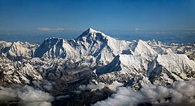
ເຂົາເອເວີເຣສຕ໌
| ຍອດເຂົາ ເອເວີເຣຕສ໌ | |
|---|---|
 ພາບຖ່າຍທາງອາກາດຈາກທິດໃຕ້ຫລັງ Nuptse ແລະ Lhotse | |
| ຄວາມສູງຈາກລະດັບນ້ຳທະເລ | 8,848.86 ແມັດ (29,031.7 ຟຸດ) ອັນດັບ 1 ໃນບັນດາ ຍອດເຂົາແປດພັນແມັດ (Eight-thousander) |
| ພິກັດພູມສາດ: | 27°59′17″N 86°55′31″E / 27.98806°N 86.92528°Eພິກັດພູມສາດ: 27°59′17″N 86°55′31″E / 27.98806°N 86.92528°E |
| ທີ່ຕັ້ງ: | ຊາຍແດນລະຫວ່າງ ປະເທດເນປານແລະ ຕິເບດ |
| ເທືອກເຂົາ: | ຫິມະໄລ |
| ການໄຕ່ຂຶ້ນສູ່ຍອດພູຄັ້ງທຳອິດ (first ascent) : | ໂດຍ (Edmund Hillary) ແລະ (Tenzing Norgay) ໃນວັນທີ 29 ພຶດສະພາ ຄສ 1953 |
| ເສັ້ນທາງປີນເຂົາ (climbing route) ທີ່ງ່າຍສຸດ: | ຈາກ (South Col) ປະເທດເນປານ |
Mount Everest ( ພາສາຈີນ :珠穆朗玛Zhūmùlǎngmǎ ; Nepali Sagarmāthā ; ທິເບດ : Chomolungma ཇོ་མོ་གླང་མ ) ເປັນ ພູທີ່ສູງທີ່ສຸດຂອງໂລກ ເໜືອ ລະດັບນ້ຳທະເລ, ຕັ້ງຢູ່ໃນສາຍພູຍ່ອຍ Mahalangur Himal ຂອງ ຮິມາລາຢາ . ຊາຍແດນຈີນ - ເນປານ ແລ່ນຜ່ານ ຈຸດສຸດຍອດຂອງມັນ. ຄວາມສູງຂອງມັນ (ຄວາມສູງຫິມະ) 8,848.86 m (29,031,7 ft) .[2]
- ↑ The WGS84 coordinates given here were calculated using detailed topographic mapping and are in agreement with adventurestats. They are unlikely to be in error by more than 2". Coordinates showing Everest to be more than a minute further east that appeared on this page until recently, and still appear in Wikipedia in several other languages, are incorrect.
- ↑ "Mount Everest is two feet taller, China and Nepal announce", National Geographic