ຮູບ:Vanuatu location map.svg

Size of this PNG preview of this SVG file: 324 × 599 ພິກເຊວ. ຄວາມລະອຽດອື່ນ ໆ: 130 × 240 ພິກເຊວ | 259 × 480 ພິກເຊວ | 415 × 768 ພິກເຊວ | 553 × 1,024 ພິກເຊວ | 1,107 × 2,048 ພິກເຊວ | 625 × 1,156 ພິກເຊວ
ໄຟລ໌ຕົ້ນສະບັບ (SVG file, nominally 625 × 1,156 pixels, file size: 79 KB)
ສະຫຼຸບ
| Camera location | | View this and other nearby images on: OpenStreetMap |
|---|
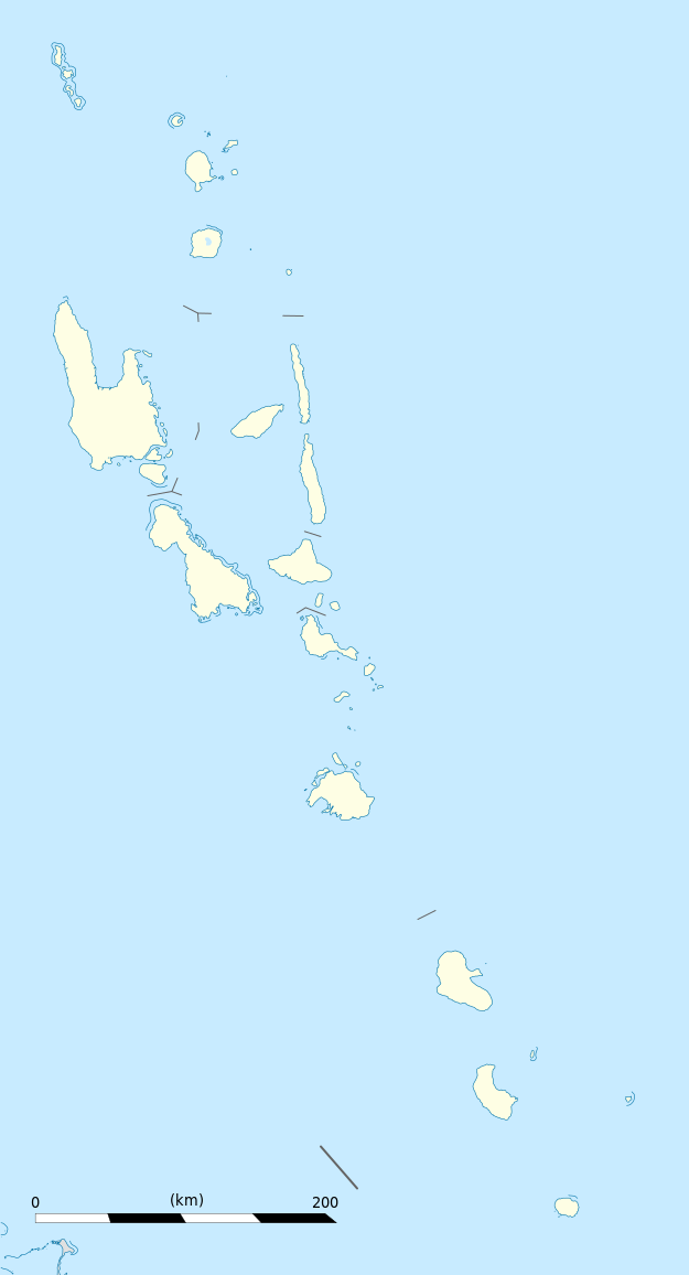
| ລາຍລະອຽດ |
Equirectangular projection, WGS84 datum
Geographic limits of the map:
|
||
| ວັນທີ | |||
| Source |
Own work
|
||
| ຜູ້ຂຽນ | Eric Gaba (Sting - fr:Sting) | ||
| Permission (Reusing this file) |
|
||
| Other versions |
|

Licensing
I, the copyright holder of this work, hereby publish it under the following licenses:
This file is licensed under the Creative Commons Attribution-Share Alike 3.0 Unported license.
- You are free:
- to share – to copy, distribute and transmit the work
- to remix – to adapt the work
- Under the following conditions:
- ສະແດງທີ່ມາ – You must give appropriate credit, provide a link to the license, and indicate if changes were made. You may do so in any reasonable manner, but not in any way that suggests the licensor endorses you or your use.
- ແບ່ງປັນຄືກັນ – If you remix, transform, or build upon the material, you must distribute your contributions under the same or compatible license as the original.

|
Permission is granted to copy, distribute and/or modify this document under the terms of the GNU Free Documentation License, Version 1.2 or any later version published by the Free Software Foundation; with no Invariant Sections, no Front-Cover Texts, and no Back-Cover Texts. A copy of the license is included in the section entitled GNU Free Documentation License. |
You may select the license of your choice.
ປະຫວັດໄຟລ໌
ຄລິກທີ່ ວັນທີ/ເວລາ ເພື່ອເບິ່ງໄຟລ໌ດັ່ງທີ່ມັນປາກົດໃນເວລານັ້ນ
| ວັນເວລາ | ຮູບຍໍ່ | ມິຕິ | ຜູ້ໃຊ້ | ຄວາມເຫັນ | |
|---|---|---|---|---|---|
| ປະຈຸບັນ | 19:02, 21 ຕຸລາ 2013 | | 625 × 1,156(79 KB) | TUBS | +provincial seaborders and matching int'l maritime borders |
| 22:12, 21 ມັງກອນ 2009 |  | 625 × 1,156(134 KB) | Sting | == Summary == {{Location|16|42|00|S|168|24|00|E|scale:3000000}} <br/> {{Information |Description={{en|Blank administrative map of Vanuatu in Oceania, for geo-location purposes.}} {{fr|Carte administrative vierge de [[:fr:Va |
ການໃຊ້ໄຟລ໌
ບໍ່ມີໜ້າໃດ ລິ້ງຄ໌ ຫາ ໄຟລ໌ນີ້.
ການໃຊ້ໄຟລ໌ທົ່ວໂລກ
ວິກິອື່ນ ໆ ຕໍ່ໄປນີ້ໃຊ້ໄຟລ໌ນີ້:
- ການໃຊ້ງານເທິງ af.wikipedia.org
- ການໃຊ້ງານເທິງ an.wikipedia.org
- ການໃຊ້ງານເທິງ ar.wikipedia.org
- ການໃຊ້ງານເທິງ ast.wikipedia.org
- Puertu Villa
- Módulu:Mapa de llocalización/datos/Vanuatu
- Módulu:Mapa de llocalización/datos/Vanuatu/usu
- Aeropuertu Internacional Bauerfield
- Aeropuertu Internacional de Santo-Pekoa
- Malakula
- Aore
- Luganville (Vanuatu)
- Monte Tabwemasana
- Maewo
- Erromango
- Islla de Pentecostés
- Aneityum
- Vanua Lava
- Islla Epi
- Ambae
- Gaua
- Efate
- Islla Espíritu Santo (Vanuatu)
- Ambrym
- Islla Tanna
- ການໃຊ້ງານເທິງ az.wikipedia.org
- ການໃຊ້ງານເທິງ ba.wikipedia.org
- ການໃຊ້ງານເທິງ be-tarask.wikipedia.org
- ການໃຊ້ງານເທິງ be.wikipedia.org
- ການໃຊ້ງານເທິງ bg.wikipedia.org
- ການໃຊ້ງານເທິງ bn.wikipedia.org
- ການໃຊ້ງານເທິງ bs.wikipedia.org
- ການໃຊ້ງານເທິງ ceb.wikipedia.org
View more global usage of this file.