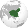
ຮູບ:Qing dynasty in 1760.svg

Size of this PNG preview of this SVG file: 600 × 600 ພິກເຊວ. ຄວາມລະອຽດອື່ນ ໆ: 240 × 240 ພິກເຊວ | 480 × 480 ພິກເຊວ | 768 × 768 ພິກເຊວ | 1,024 × 1,024 ພິກເຊວ | 2,048 × 2,048 ພິກເຊວ
ໄຟລ໌ຕົ້ນສະບັບ (SVG file, nominally 600 × 600 pixels, file size: 472 KB)
ປະຫວັດໄຟລ໌
ຄລິກທີ່ ວັນທີ/ເວລາ ເພື່ອເບິ່ງໄຟລ໌ດັ່ງທີ່ມັນປາກົດໃນເວລານັ້ນ
| ວັນເວລາ | ຮູບຍໍ່ | ມິຕິ | ຜູ້ໃຊ້ | ຄວາມເຫັນ | |
|---|---|---|---|---|---|
| ປະຈຸບັນ | 03:49, 24 ກັນຍາ 2023 |  | 600 × 600(472 KB) | Cactus Ronin | Reverted to version as of 16:06, 28 September 2022 (UTC) |
| 03:15, 24 ກັນຍາ 2023 |  | 600 × 600(475 KB) | Cactus Ronin | There is no ardchaeological nor documental evidence for Sakhalin being a Qing territory, except for "fur tributary" system. If being a "tributary" is enough to make one territory of another then we should attribute almost all of the world to British Empire, including Qing Dynasty, shall we? | |
| 16:06, 28 ກັນຍາ 2022 |  | 600 × 600(472 KB) | Aldermanseven | changes based on File:China in 1820.svg | |
| 19:28, 27 ກັນຍາ 2022 |  | 600 × 600(468 KB) | Aldermanseven | Uploaded own work with UploadWizard |
ການໃຊ້ໄຟລ໌
ໜ້າຕໍ່ໄປນີ້ເຊື່ອມໂຍງຫາໄຟລ໌ນີ້:
ການໃຊ້ໄຟລ໌ທົ່ວໂລກ
ວິກິອື່ນ ໆ ຕໍ່ໄປນີ້ໃຊ້ໄຟລ໌ນີ້:
- ການໃຊ້ງານເທິງ af.wikipedia.org
- ການໃຊ້ງານເທິງ alt.wikipedia.org
- ການໃຊ້ງານເທິງ ar.wikipedia.org
- ການໃຊ້ງານເທິງ bcl.wikipedia.org
- ການໃຊ້ງານເທິງ ca.wikipedia.org
- ການໃຊ້ງານເທິງ ce.wikipedia.org
- ການໃຊ້ງານເທິງ en.wikipedia.org
- ການໃຊ້ງານເທິງ es.wikipedia.org
- ການໃຊ້ງານເທິງ fa.wikipedia.org
- ການໃຊ້ງານເທິງ fi.wikipedia.org
- ການໃຊ້ງານເທິງ fr.wikipedia.org
- ການໃຊ້ງານເທິງ id.wikipedia.org
- ການໃຊ້ງານເທິງ incubator.wikimedia.org
- ການໃຊ້ງານເທິງ ja.wikipedia.org
- ການໃຊ້ງານເທິງ ko.wikipedia.org
- ການໃຊ້ງານເທິງ lld.wikipedia.org
- ການໃຊ້ງານເທິງ mni.wikipedia.org
- ການໃຊ້ງານເທິງ mn.wikipedia.org
- ການໃຊ້ງານເທິງ ru.wikipedia.org
- ການໃຊ້ງານເທິງ simple.wikipedia.org
- ການໃຊ້ງານເທິງ sq.wikipedia.org
- ການໃຊ້ງານເທິງ th.wikipedia.org
- ການໃຊ້ງານເທິງ ts.wikipedia.org
- ການໃຊ້ງານເທິງ uk.wikipedia.org
- ການໃຊ້ງານເທິງ uk.wikiquote.org
- ການໃຊ້ງານເທິງ zh.wikipedia.org
View more global usage of this file.
