ຮູບ:Irrawaddyrivermap.jpg
ຂະໜາດຂອງຕົວຢ່າງນີ້: 421 × 599 ພິກເຊວ ຄວາມລະອຽດອື່ນ ໆ: 168 × 240 ພິກເຊວ | 337 × 480 ພິກເຊວ | 862 × 1,227 ພິກເຊວ
ໄຟລ໌ຕົ້ນສະບັບ (862 × 1,227 ປິກເຊລ, ຂະໜາດໄຟລ໌: 208 KB, MIME type: image/jpeg)
ສະຫຼຸບ
| ລາຍລະອຽດ |
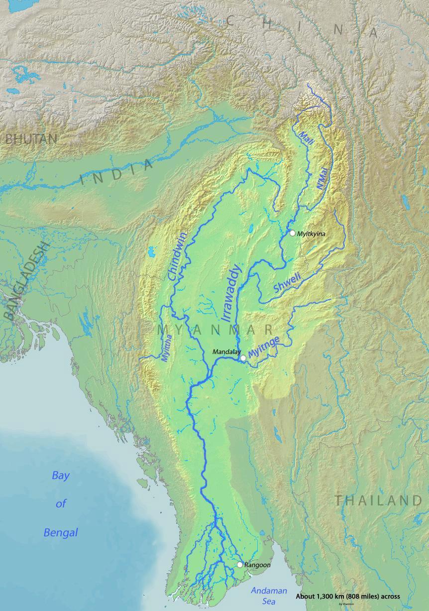
English: Map of the Irrawaddy River, which drains parts of Myanmar (Burma), Thailand and India into the Andaman Sea Français : Carte de l'Irrawaddy. Myitnge |
| ວັນທີ | |
| Source | Background and river course data from http://www2.demis.nl/mapserver/mapper.asp |
| ຜູ້ຂຽນ | Shannon |
Licensing
I, the copyright holder of this work, hereby publish it under the following licenses:

|
Permission is granted to copy, distribute and/or modify this document under the terms of the GNU Free Documentation License, Version 1.2 or any later version published by the Free Software Foundation; with no Invariant Sections, no Front-Cover Texts, and no Back-Cover Texts. A copy of the license is included in the section entitled GNU Free Documentation License. |
This file is licensed under the Creative Commons Attribution-Share Alike 4.0 International, 3.0 Unported, 2.5 Generic, 2.0 Generic and 1.0 Generic license.
- You are free:
- to share – to copy, distribute and transmit the work
- to remix – to adapt the work
- Under the following conditions:
- ສະແດງທີ່ມາ – You must give appropriate credit, provide a link to the license, and indicate if changes were made. You may do so in any reasonable manner, but not in any way that suggests the licensor endorses you or your use.
- ແບ່ງປັນຄືກັນ – If you remix, transform, or build upon the material, you must distribute your contributions under the same or compatible license as the original.
You may select the license of your choice.
ປະຫວັດໄຟລ໌
ຄລິກທີ່ ວັນທີ/ເວລາ ເພື່ອເບິ່ງໄຟລ໌ດັ່ງທີ່ມັນປາກົດໃນເວລານັ້ນ
| ວັນເວລາ | ຮູບຍໍ່ | ມິຕິ | ຜູ້ໃຊ້ | ຄວາມເຫັນ | |
|---|---|---|---|---|---|
| ປະຈຸບັນ | 00:32, 1 ທັນວາ 2015 | | 862 × 1,227(208 KB) | Xufanc | Myittha River |
| 08:30, 30 ພະຈິກ 2015 |  | 862 × 1,227(208 KB) | Xufanc | Reverted to version as of 08:22, 30 November 2015 (UTC) | |
| 08:28, 30 ພະຈິກ 2015 |  | 862 × 1,227(208 KB) | Xufanc | Reverted to version as of 08:18, 30 November 2015 (UTC) | |
| 08:25, 30 ພະຈິກ 2015 |  | 862 × 1,227(208 KB) | Xufanc | Reverted to version as of 08:18, 30 November 2015 (UTC) | |
| 08:22, 30 ພະຈິກ 2015 |  | 862 × 1,227(208 KB) | Xufanc | added name of tributary | |
| 08:18, 30 ພະຈິກ 2015 |  | 862 × 1,227(208 KB) | Xufanc | added name of tributary | |
| 06:38, 24 ກັນຍາ 2014 |  | 862 × 1,227(219 KB) | Xufanc | Corrected wrong label | |
| 04:06, 3 ມີນາ 2010 |  | 862 × 1,227(653 KB) | Shannon1 | {{Information |Description={{en|1=Map of the Irrawaddy River, which drains parts of Myanmar (Burma), Thailand and India into the Andaman Sea}} |Source=Background and river course data from http://www2.demis.nl/mapserver/mapper.asp |Author=[[User:Shannonc |
ການໃຊ້ໄຟລ໌
ໜ້າຕໍ່ໄປນີ້ເຊື່ອມໂຍງຫາໄຟລ໌ນີ້:
ການໃຊ້ໄຟລ໌ທົ່ວໂລກ
ວິກິອື່ນ ໆ ຕໍ່ໄປນີ້ໃຊ້ໄຟລ໌ນີ້:
- ການໃຊ້ງານເທິງ af.wikipedia.org
- ການໃຊ້ງານເທິງ ar.wikipedia.org
- ການໃຊ້ງານເທິງ ast.wikipedia.org
- ການໃຊ້ງານເທິງ azb.wikipedia.org
- ການໃຊ້ງານເທິງ be-tarask.wikipedia.org
- ການໃຊ້ງານເທິງ bg.wikipedia.org
- ການໃຊ້ງານເທິງ bh.wikipedia.org
- ການໃຊ້ງານເທິງ blk.wikipedia.org
- ການໃຊ້ງານເທິງ bn.wikipedia.org
- ການໃຊ້ງານເທິງ br.wikipedia.org
- ການໃຊ້ງານເທິງ ca.wikipedia.org
- ການໃຊ້ງານເທິງ cs.wikipedia.org
- ການໃຊ້ງານເທິງ cy.wikipedia.org
- ການໃຊ້ງານເທິງ de.wikipedia.org
- ການໃຊ້ງານເທິງ en.wikipedia.org
- ການໃຊ້ງານເທິງ en.wikinews.org
- ການໃຊ້ງານເທິງ es.wikipedia.org
- ການໃຊ້ງານເທິງ eu.wikipedia.org
- ການໃຊ້ງານເທິງ fa.wikipedia.org
- ການໃຊ້ງານເທິງ fr.wikipedia.org
- ການໃຊ້ງານເທິງ gl.wikipedia.org
- ການໃຊ້ງານເທິງ hi.wikipedia.org
- ການໃຊ້ງານເທິງ hr.wikipedia.org
- ການໃຊ້ງານເທິງ hu.wikipedia.org
- ການໃຊ້ງານເທິງ hy.wikipedia.org
- ການໃຊ້ງານເທິງ id.wikipedia.org
- ການໃຊ້ງານເທິງ ja.wikipedia.org
- ການໃຊ້ງານເທິງ ka.wikipedia.org
- ການໃຊ້ງານເທິງ ko.wikipedia.org
- ການໃຊ້ງານເທິງ mk.wikipedia.org
- ການໃຊ້ງານເທິງ ml.wikipedia.org
- ການໃຊ້ງານເທິງ my.wikipedia.org
View more global usage of this file.