ຮູບ:Afghanistan physical en.png

ຂະໜາດຂອງຕົວຢ່າງນີ້: 768 × 600 ພິກເຊວ ຄວາມລະອຽດອື່ນ ໆ: 307 × 240 ພິກເຊວ | 615 × 480 ພິກເຊວ | 983 × 768 ພິກເຊວ | 1,280 × 1,000 ພິກເຊວ | 2,079 × 1,624 ພິກເຊວ
ໄຟລ໌ຕົ້ນສະບັບ (2,079 × 1,624 ປິກເຊລ, ຂະໜາດໄຟລ໌: 4.46 MB, MIME type: image/png)
ສະຫຼຸບ
| ລາຍລະອຽດ |
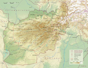
Physical map of Afghanistan, administrative division into 34 provinces following the administrative reform from 2005. (Here is one more map, not on commons, on www.ezilon.com/maps: Physical Map of Afghanistan) |
| ວັນທີ | |
| Source | Selfmade, based on topographic data: SRTM30 V2.1 |
| ຜູ້ຂຽນ | User:Sommerkom |
| Other versions |
|

Licensing
I, the copyright holder of this work, hereby publish it under the following license:
This file is licensed under the Creative Commons Attribution-Share Alike 3.0 Unported license.
- You are free:
- to share – to copy, distribute and transmit the work
- to remix – to adapt the work
- Under the following conditions:
- ສະແດງທີ່ມາ – You must give appropriate credit, provide a link to the license, and indicate if changes were made. You may do so in any reasonable manner, but not in any way that suggests the licensor endorses you or your use.
- ແບ່ງປັນຄືກັນ – If you remix, transform, or build upon the material, you must distribute your contributions under the same or compatible license as the original.
ປະຫວັດໄຟລ໌
ຄລິກທີ່ ວັນທີ/ເວລາ ເພື່ອເບິ່ງໄຟລ໌ດັ່ງທີ່ມັນປາກົດໃນເວລານັ້ນ
| ວັນເວລາ | ຮູບຍໍ່ | ມິຕິ | ຜູ້ໃຊ້ | ຄວາມເຫັນ | |
|---|---|---|---|---|---|
| ປະຈຸບັນ | 12:43, 10 ກັນຍາ 2010 | | 2,079 × 1,624(4.46 MB) | Sommerkom | == Beschreibung, Quelle == {{Information |Beschreibung = Physical map of Afghanistan, administrative division into 34 provinces following the administrative reform from 2005. |Quelle = Selfmade, topographic data: [http://www2.jpl.nasa.gov/srtm/index.html |
ການໃຊ້ໄຟລ໌
ໜ້າຕໍ່ໄປນີ້ເຊື່ອມໂຍງຫາໄຟລ໌ນີ້:
ການໃຊ້ໄຟລ໌ທົ່ວໂລກ
ວິກິອື່ນ ໆ ຕໍ່ໄປນີ້ໃຊ້ໄຟລ໌ນີ້:
- ການໃຊ້ງານເທິງ af.wikipedia.org
- ການໃຊ້ງານເທິງ ar.wikipedia.org
- ການໃຊ້ງານເທິງ ast.wikipedia.org
- ການໃຊ້ງານເທິງ bcl.wikipedia.org
- ການໃຊ້ງານເທິງ bg.wikipedia.org
- ການໃຊ້ງານເທິງ ckb.wikipedia.org
- ການໃຊ້ງານເທິງ de.wikipedia.org
- ການໃຊ້ງານເທິງ en.wikipedia.org
- ການໃຊ້ງານເທິງ es.wikipedia.org
- ການໃຊ້ງານເທິງ fr.wikipedia.org
- ການໃຊ້ງານເທິງ hu.wikipedia.org
- ການໃຊ້ງານເທິງ hy.wikipedia.org
- ການໃຊ້ງານເທິງ ja.wikipedia.org
- ການໃຊ້ງານເທິງ ka.wikipedia.org
- ການໃຊ້ງານເທິງ ko.wikipedia.org
- ການໃຊ້ງານເທິງ lv.wikipedia.org
- ການໃຊ້ງານເທິງ mt.wikipedia.org
- ການໃຊ້ງານເທິງ my.wikipedia.org
- ການໃຊ້ງານເທິງ or.wikipedia.org
- ການໃຊ້ງານເທິງ pl.wikipedia.org
- ການໃຊ້ງານເທິງ sd.wikipedia.org
- ການໃຊ້ງານເທິງ tay.wikipedia.org
- ການໃຊ້ງານເທິງ te.wikipedia.org
- ການໃຊ້ງານເທິງ to.wikipedia.org
- ການໃຊ້ງານເທິງ uk.wikipedia.org
- ການໃຊ້ງານເທິງ ur.wikipedia.org
- ການໃຊ້ງານເທິງ vi.wikipedia.org
- ການໃຊ້ງານເທິງ zh.wikipedia.org