ຮູບ:Mediterranee 02 EN.jpg

ຂະໜາດຂອງຕົວຢ່າງນີ້: 800 × 488 ພິກເຊວ ຄວາມລະອຽດອື່ນ ໆ: 320 × 195 ພິກເຊວ | 640 × 390 ພິກເຊວ | 1,024 × 625 ພິກເຊວ | 1,500 × 915 ພິກເຊວ
ໄຟລ໌ຕົ້ນສະບັບ (1,500 × 915 ປິກເຊລ, ຂະໜາດໄຟລ໌: 562 KB, MIME type: image/jpeg)
ສະຫຼຸບ
| ລາຍລະອຽດ |
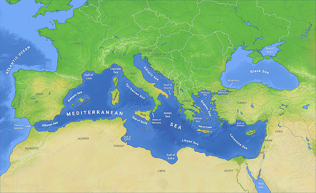
English: Map of the Mediterranean Sea with subdivisions, straits, islands and countries |
| ວັນທີ | |
| Source | Own work |
| ຜູ້ຂຽນ | O H 237 |
Licensing
I, the copyright holder of this work, hereby publish it under the following license:
This file is licensed under the Creative Commons Attribution-Share Alike 4.0 International license.
- You are free:
- to share – to copy, distribute and transmit the work
- to remix – to adapt the work
- Under the following conditions:
- ສະແດງທີ່ມາ – You must give appropriate credit, provide a link to the license, and indicate if changes were made. You may do so in any reasonable manner, but not in any way that suggests the licensor endorses you or your use.
- ແບ່ງປັນຄືກັນ – If you remix, transform, or build upon the material, you must distribute your contributions under the same or compatible license as the original.
ປະຫວັດໄຟລ໌
ຄລິກທີ່ ວັນທີ/ເວລາ ເພື່ອເບິ່ງໄຟລ໌ດັ່ງທີ່ມັນປາກົດໃນເວລານັ້ນ
| ວັນເວລາ | ຮູບຍໍ່ | ມິຕິ | ຜູ້ໃຊ້ | ຄວາມເຫັນ | |
|---|---|---|---|---|---|
| ປະຈຸບັນ | 15:16, 13 ກຸມພາ 2015 | | 1,500 × 915(562 KB) | O H 237 | Translation completed |
| 15:12, 13 ກຸມພາ 2015 |  | 1,500 × 915(562 KB) | O H 237 | User created page with UploadWizard |
ການໃຊ້ໄຟລ໌
ໜ້າຕໍ່ໄປນີ້ເຊື່ອມໂຍງຫາໄຟລ໌ນີ້:
ການໃຊ້ໄຟລ໌ທົ່ວໂລກ
ວິກິອື່ນ ໆ ຕໍ່ໄປນີ້ໃຊ້ໄຟລ໌ນີ້:
- ການໃຊ້ງານເທິງ ady.wikipedia.org
- ການໃຊ້ງານເທິງ af.wikipedia.org
- ການໃຊ້ງານເທິງ anp.wikipedia.org
- ການໃຊ້ງານເທິງ ar.wikipedia.org
- ການໃຊ້ງານເທິງ ary.wikipedia.org
- ການໃຊ້ງານເທິງ as.wikipedia.org
- ການໃຊ້ງານເທິງ be-tarask.wikipedia.org
- ການໃຊ້ງານເທິງ bh.wikipedia.org
- ການໃຊ້ງານເທິງ bn.wikipedia.org
- ການໃຊ້ງານເທິງ bs.wikipedia.org
- ການໃຊ້ງານເທິງ ca.wikipedia.org
- ການໃຊ້ງານເທິງ cdo.wikipedia.org
- ການໃຊ້ງານເທິງ ckb.wikipedia.org
- ການໃຊ້ງານເທິງ cs.wikipedia.org
- ການໃຊ້ງານເທິງ da.wiktionary.org
- ການໃຊ້ງານເທິງ el.wikiversity.org
- ການໃຊ້ງານເທິງ en.wikipedia.org
- ການໃຊ້ງານເທິງ en.wikiversity.org
- ການໃຊ້ງານເທິງ en.wiktionary.org
- ການໃຊ້ງານເທິງ es.wikipedia.org
- ການໃຊ້ງານເທິງ fa.wikipedia.org
- ການໃຊ້ງານເທິງ fy.wikipedia.org
- ການໃຊ້ງານເທິງ hi.wikipedia.org
- ການໃຊ້ງານເທິງ hyw.wikipedia.org
- ການໃຊ້ງານເທິງ id.wikipedia.org
- ການໃຊ້ງານເທິງ ilo.wikipedia.org
- ການໃຊ້ງານເທິງ incubator.wikimedia.org
- ການໃຊ້ງານເທິງ it.wiktionary.org
- ການໃຊ້ງານເທິງ kcg.wikipedia.org
- ການໃຊ້ງານເທິງ ku.wikipedia.org
- ການໃຊ້ງານເທິງ la.wikipedia.org
- ການໃຊ້ງານເທິງ mai.wikipedia.org
- ການໃຊ້ງານເທິງ mk.wikipedia.org
- ການໃຊ້ງານເທິງ ml.wikipedia.org
- ການໃຊ້ງານເທິງ ms.wikipedia.org
- ການໃຊ້ງານເທິງ my.wikipedia.org
- ການໃຊ້ງານເທິງ ne.wikipedia.org
- ການໃຊ້ງານເທິງ sat.wikipedia.org
View more global usage of this file.