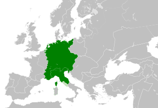
ຮູບ:Holy Roman Empire 1190.svg

Size of this PNG preview of this SVG file: 550 × 375 ພິກເຊວ. ຄວາມລະອຽດອື່ນ ໆ: 320 × 218 ພິກເຊວ | 640 × 436 ພິກເຊວ | 1,024 × 698 ພິກເຊວ | 1,280 × 873 ພິກເຊວ | 2,560 × 1,745 ພິກເຊວ
ໄຟລ໌ຕົ້ນສະບັບ (SVG file, nominally 550 × 375 pixels, file size: 1,005 KB)
ສະຫຼຸບ
This W3C-unspecified vector image was created with Inkscape .


.svg)
.svg)
.svg)
.svg)
.svg)


.svg)
.svg)
.svg)


.png)
.png)


.svg)


.svg)

.svg)


.svg)
.svg)
.svg)
.svg)


.svg)
.png)


.svg)


.svg)
.svg)


.svg)


.svg)


.svg)
.svg)
.svg)
.svg)
.svg)
.svg)
.svg)
_cropped.svg)
.svg)
.svg)
.svg)
.svg)
.svg)
.svg)
.svg)
.svg)
.svg)
.svg)
.svg)
.svg)
.svg)
.svg)
.svg)
.svg)
.svg)
.svg)
.svg)
.svg)
.svg)
.svg)
.svg)
.svg)
.svg)
.svg)
.svg)
.svg)
.svg)
.svg)
.svg)
.svg)
.svg)
.svg)
.svg)
.svg)
.svg)
.svg)
.svg)
.svg)
.svg)
.svg)
.svg)
.svg)
.svg)
Licensing
This file is licensed under the Creative Commons Attribution-Share Alike 4.0 International license.
- You are free:
- to share – to copy, distribute and transmit the work
- to remix – to adapt the work
- Under the following conditions:
- ສະແດງທີ່ມາ – You must give appropriate credit, provide a link to the license, and indicate if changes were made. You may do so in any reasonable manner, but not in any way that suggests the licensor endorses you or your use.
- ແບ່ງປັນຄືກັນ – If you remix, transform, or build upon the material, you must distribute your contributions under the same or compatible license as the original.
ປະຫວັດໄຟລ໌
ຄລິກທີ່ ວັນທີ/ເວລາ ເພື່ອເບິ່ງໄຟລ໌ດັ່ງທີ່ມັນປາກົດໃນເວລານັ້ນ
| ວັນເວລາ | ຮູບຍໍ່ | ມິຕິ | ຜູ້ໃຊ້ | ຄວາມເຫັນ | |
|---|---|---|---|---|---|
| ປະຈຸບັນ | 20:41, 29 ສິງຫາ 2021 | | 550 × 375(1,005 KB) | Nancystodd | Corrected status of Sardinia, which was not part of the Holy Roman Empire. |
| 22:28, 30 ພຶດສະພາ 2016 |  | 550 × 375(994 KB) | Alphathon | corrected/refined HRE-Venitian and German-Italian borders | |
| 16:20, 29 ພຶດສະພາ 2016 |  | 485 × 375(909 KB) | Alphathon | Cropped | |
| 16:04, 29 ພຶດສະພາ 2016 |  | 550 × 375(998 KB) | Alphathon | == {{int:filedesc}} == {{Inkscape}} {{Information |Description={{en|A map of the en:Holy Roman Empire within Europe circa 1190 CE. Note that the borders of the Cumans, Kipchaks, Kievan Rus', Kama Bulgarians and Viatka do not extend right to... |
ການໃຊ້ໄຟລ໌
ໜ້າຕໍ່ໄປນີ້ເຊື່ອມໂຍງຫາໄຟລ໌ນີ້:
ການໃຊ້ໄຟລ໌ທົ່ວໂລກ
ວິກິອື່ນ ໆ ຕໍ່ໄປນີ້ໃຊ້ໄຟລ໌ນີ້:
- ການໃຊ້ງານເທິງ cs.wikipedia.org
- ການໃຊ້ງານເທິງ en.wikipedia.org
- ການໃຊ້ງານເທິງ fr.wikipedia.org
- ການໃຊ້ງານເທິງ it.wikipedia.org
- ການໃຊ້ງານເທິງ ko.wikipedia.org
- ການໃຊ້ງານເທິງ pt.wikipedia.org
- ການໃຊ້ງານເທິງ th.wikipedia.org